SOFTWARE & APPLICATIONS
XLOCATE


DESCRIPTION
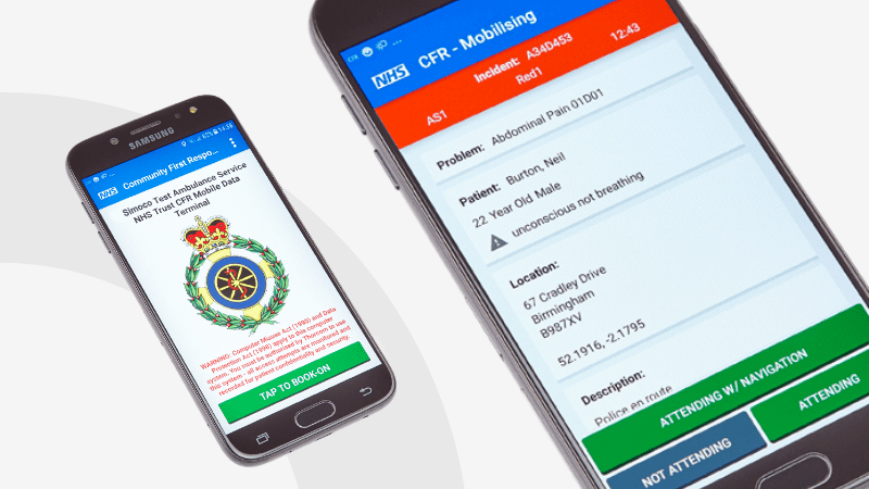
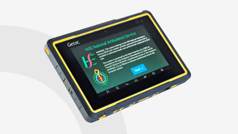
Xlocate is a fast, scalable, and ultra-reliable real-time mapping solution designed for critical command and control applications. Whether in emergency response, battlefield operations, or disaster scenarios, Xlocate ensures seamless location tracking when conventional communications fail.
Stay connected, stay in control—wherever duty calls.
Why Choose Xlocate?
- Resilient & Secure – Mixes location updates across TETRA, LTE, and WiFi networks for uninterrupted tracking.
- Cross-Platform & Multi-Device – Supports Android handheld devices and integrates seamlessly with Thorcom-SIMOCO’s Xlocate Gateway.
- Built for Critical Users – Ideal for Critical National Infrastructure (CNI), with P25/DMR compatibility for enhanced operational efficiency.
- Ultra-Fast & Scalable – Designed for high-performance real-time location display across diverse field-based devices.
Unlike traditional GIS solutions, Xlocate is purpose-built for mission-critical environments, providing secure, real-time situational awareness when it matters most.
Central server solution
- ‘Xlocate Gateway Service’ can be provided as a resilient hosted SIMOCO software service or an on-premise solution
- Supports VR and VX (and EC) devices and App based LTE ARL (Automatic Resource Location), and Sepura and Motorola TETRA ARL
- Automatic device configuration and automatically updated map data, independent of internet connectivity for resilience
- Supports fleets of up to 10,000 devices
Client Solution
- Thin client architecture compatible with all major browsers and desktop, tablet and mobile devices
- Capable of supporting up to 250 seats per end user organisation
- Based on licence-free OpenStreetMap mapping
- Includes user Authentication and an ARL replay function of historic ARL.
Further technical info:
- Back-end is a PostgreSQL database running on Linux
- Maps are vector based, held at the server, auto updated and auto distributed to clients
- Web service is Express.js web server
- Client mapping engine is a local OpenStreetMap tile server via Leaflet.js running in a browser
TECHNICAL SPECIFICATIONS
Frequency Bands:
VHF:136–174MHz
UHF:400–480MHz
UHF:440–520MHz
Power Supply:
13.6 V DC (25 W) or 110/240V AC (refers to SDB670 (25 W) variants which are available in EMEA only.)
Frequency Stability:
+/-0.5ppm
Channel Bandwidth:
12.5/25kHz
Channel Capacity:
2000
Dimensions:
408 mm (width) x 487 mm (deep) x 88.9 mm (height) (19” rack mount)
Weight:
9.2kg / 8.7 kg
Emission Masks:
7K60FXD (data), 7K60FXE (voice), 7K60F1W (voice and data) for 4FSK digital modulation, 11K0F3E for 12.5 kHz modulation
RF Output Power:
25W
Modulation Limiting:
+/-2.5 @ 12.5kHz, +/-5.0 kHz @ 25kHz
FM Hum and Noise:
40dB (TIA-603-B)
Conducted / Radiated Emission:
Complies with ETS086-1 / ASNZS4295 / TIA603-B
Spurious emissions
-80 dBc
Adjacent Channel Power:
-60dBc (ETS086-1)
Audio Response:
+1/-3dB
Audio Distortion:
4% @ 4W
Digital Vocoder Type:
AMBE+2
-117.5dBm (12dB SINAD)
Digital Sensitivity:
-117.5dBm (BER 1%)
Intermodulation:
70dB (ETS086-1)
Adjacent Channel Selectivity:
>65 dB @ 12.5 kHz, >73 dB @ 25 kHz (ETS086-1)
Spurious Rejection:
70dB (ETS086-1)
-40dB (TIA603-B)
Audio Response:
+1/-2dB (0.3-2.55kHz)
Audio Distortion:
3% @ 4W
Conducted Spurious Emission:
-57dBm (ETS086-1)
-30°C to +60°C (DC variants), -30°C to +55°C (AC variant)
Storage Temperature:
-40°C to +80°C